London's Roman Roads
The UK Roman roads network in the UK is something we’re still very much learning about. There are no physical maps of the original Roman roads in the UK, but archaeologists continue to discover and develop what they believe once was.
Following the Romans’ invasion of the British Isles (led by the Roman Emperor Claudius) way back in the year 43, they’d embarked upon creating a new road system in order to transport troops and produce across the newly-conquered land. As with road systems today, the original Roman roads in the UK grew and spread with their signature straight roads leading to other similar straight roads leading them to other parts of the Country with Londinium (London) — our capital, in which was founded by the Romans all those years ago — as its hub.
Once the Roman empire had retreated some five thousand years later, these UK Roman roads had become lost when they were subsequently converted to more modern paths or since covered or removed completely.
Here’s what we know so far:
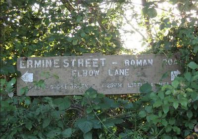
Ermine Street. Once a very major Roman road in London running from London to Lincoln and as far as York. Beginning at Bishopsgate (a point in which one of the original gates to the wall surrounding Roman London was situated) it runs through Shoreditch High Street over to Stoke Newington and going up through Tottenham, Edmonton and Enfield forming what is now known as the A10 to Royston, Hertfordshire.
Watling Street. This Roman road in London travels from Park Lane/Marble Arch, London, going up to St Albans and running along the A5/Edgeware and A5183 roads, using a natural ford near Westminster. The original track was used by the Britons until the Romans later paved it out to connect the Kentish ports of Dover, Richborough, Lympne and Reculver to the London Bridge — now the A2.
Unknown road. A Roman road in London heading north-east from London to Chelmsford and Colchester. Starting at what is now Old Street, it follows Hackney Road and Old Ford to join the A118, crossing Ermine Street at Shoreditch.
Stane Street. Stane Street is a 56-mile stretch of Roman road in London that heads south-west from London to Chichester, following Horsham. Today, the route can be closely tracked using the A3, A24, A29 and A285.
London to Brighton Way. An original Roman road running from Stane Street, Kennington Park, to Portslade, Brighton, passing through Streatham and Croydon is it goes. It follows a typical UK Roman roads construction of a straight line through the likes of Ardingly through to Clayton before crossing the Sussex Greensand Way (the site of a large Roman cemetery). The UK Roman roads route from there remains unknown but is believed to follow on to Brighton. Little trace remains to exist.
London to Lewes Way. 44miles of road travelling from Watling Street, in Peckham, London, through to Lewes, Sussex makes up the London to Lewes Way. The original Roman road in London would then link up with the likes of the aforementioned Sussex Greensand Way at Barcombe Mills along with another network of tracks.
Portway. Heading west out of London and starting along Farringdon Road, down Oxford Street and through Staines, the Portway was once known as the main route from London to Dorchester.
And that’s just a few of the Roman roads in the UK that we know about, UK Roman roads and tracks, built and used by the Romans, are being discovered and foraged every day by archaeologists and enthusiasts alike. If you’d like to follow along these ancient Roman roads in the UK consider renting a car in London.